


Discover PA - 综合地球物理软件
Discover PA是分析和显示地球梳理数据,如电磁波数据和重力数据资料、地图和三维显示的一款软件。Discover PA地球物理数据综合绘图解释平台,它能够帮助地球科学家更地对数据和地质模型进行研究、处理和解释。Discover PA大大改进了大规模数据的网格化功能和滤波功能,以及对航空物探数据进行检查的功能,它还可以把SEGY地震剖面合并进来进行综合解释。
Discover PA作为一款综合地球物理数据处理软件,Discover PA可以在软件环境下可以把地球物理数据以点、线、列、网格、钻孔和模型的形式进行处理,可以处理的地面和航空物探数据:磁法、重力、电磁法数据等。Discover PA为创建解释成果提供了功能的工作环境,可以进行异常提取、平面图解释、剖面图解释和三维地质模型的创建。
优点:
-
在软件环境下,创建的剖面图、平面图、图片和三维图。
-
绘图图层功能,可以让您一分钟之内完成想要的修改,的绘图模板功能让您完成一幅图的同时一键可以完成同类图的绘制。
-
用一系列性能优良的处理功能、网格化功能和滤波功能提升您的勘探数据。
-
从测线和剖面数据中挑出异常数据,在二维和三维图中绘制测线和区域图。
-
剖面图和二维平面图之间的数据链接功能可以让您把数据结合到报告成果中,便于批量打印。
-
建模工具,有测线数据和区域数据创建三维模型。
-
可以显示Mapinfo格式数据,用于解释工作。
Discover PA的特点:
网格化
-
二维网格化:小曲率法、发距离权重法和三角网法等,剖面数据网格化。
-
真三维网格化:分层图、反距离权重、离散(岩性)、三维克里格。
-
二维和三维工具箱提供了处理、融合、计算和脚本的三维体元模型等功能。
可以把体元三维模型和ModeIVision中的密度或磁化率数据结合起来使用。 -
对二维数据图进行拼合,这些数据图:网格图、航拍图、栅格图、矢量图、点数据图和钻探数据图。
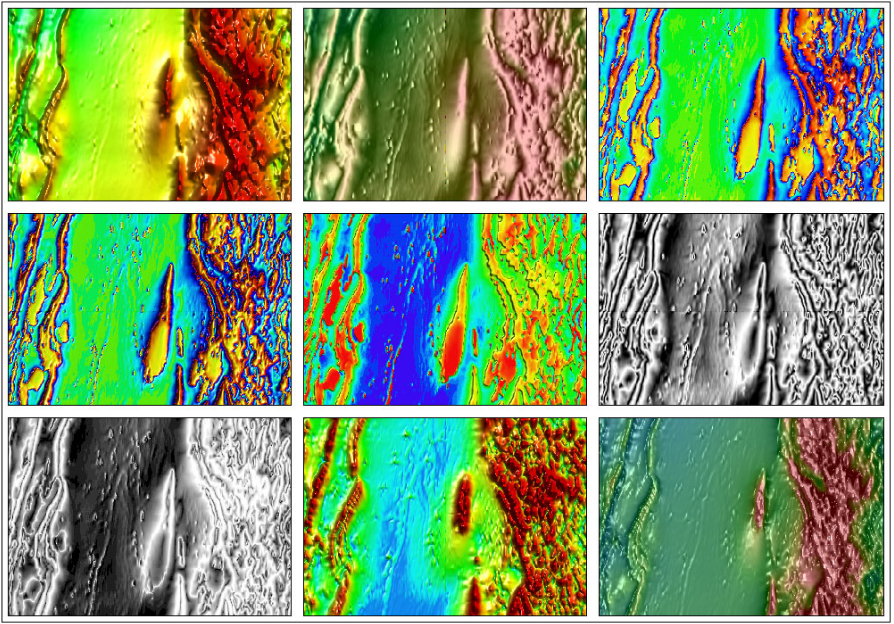
滤波和处理:
-
FFT、褶积和非线性滤波器功能,可用于测线数据和二维网格图。
-
测线滤波器:褶积、FFT和非线性方法。
-
褶积滤波器:中值滤波器、平均滤波器和自定义滤波器以及14个标准非线性滤波器。
-
非线性滤波器:AGC、中值和噪声等方法。
-
FFT滤波器:带通、延拓、求导、高通、低通、伪重力、伪磁化率、化赤。
二维解释:
异常提取:在平面图、剖面图、曲线图和三维体元图中直接链接到或提取到目标体数据,并进行批量处理。
解释要素:点、线、多边形,把这些解释内容绘制在二维图上,并即时同步到相关的二维图或三维图上。
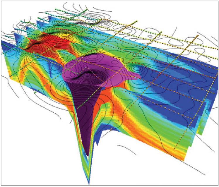
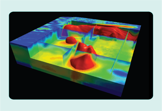
三维解释:
-
进行综合的地质解释成果,综合利用物探数据、反演模型、地球化学数据和地质数据。
-
把勘测数据变成勘测结果,在您把钻孔位置定出来的时候不存在猜测因素,创建经过球物理数据验证的三维目标体。
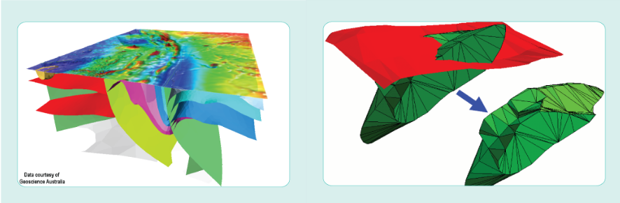
-
创建和编辑三维地质表面和封闭的体积,用它们组建复杂的三维地质模型。用Encom PA的地震深度工具可以对速度数据进行模拟,并把结果输入到三维图中,和数据进行综合解释。
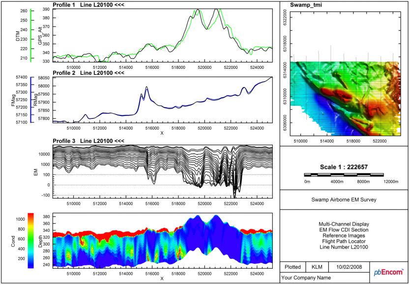
航电数据处理解释:
-
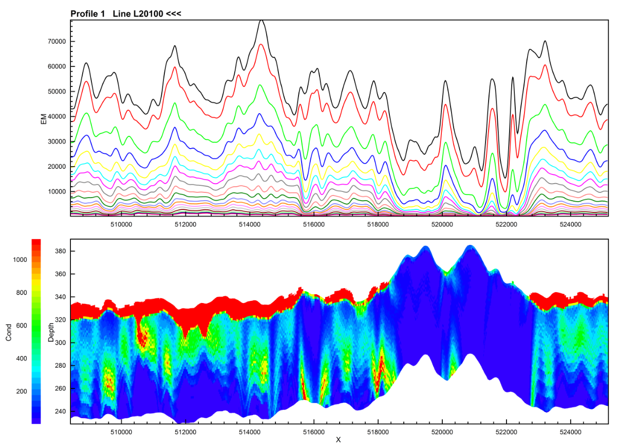
多道FEM和TEM数据的显示和提取异常。
-
综合解释一下数据:航迹图、CDI反演剖面图、飞行规划图和相关图像,例如地震图和地质剖面图。
-
在剖面图和平视图中显示体元模型。
-
在剖面图中提取异常,在CDI剖面上绘制解释成果,然后用这些连续的剖面图组合起来形成的三维解释成果。
飞行模拟:
-
进行综合地质解释成果,综合利用物探数据、反演模型、地球化学数据和地质数据
-
把勘探数据变成勘探结果,在您把钻孔位置定出来的时候不存在猜测因素,创建经过球物理数据验证的三维目标体。
英文简介:
Description:
The Discover PA family of interpretation products will change the way you work by making it easy to explore, inderpret and realize data and models of the earth . Take a closer look at Encom Discover PA Professional, Discover PA Explorer and the free Discover PA Viewer
-
Communicate your interpretations
-
Influence exploration decisions
-
Explore the limits of your data
-
Prepare the ultimate presentation
-
Fly live through a 3D project
-
Collaborate with colleagues
-
Link to your other software
-
Enhance your primary data
-
Ensure effective decision making
Discover PA fills a significant gap in your software range by providing a tool that is suited to interactive interpretation and consistent presentation of the outputs fron all your software applications . The dynamics, interaction and ease of use make this an essential tool for ensuring that you deliver the best outcomes and enjoy the experience at the same time.
Discover PA feature
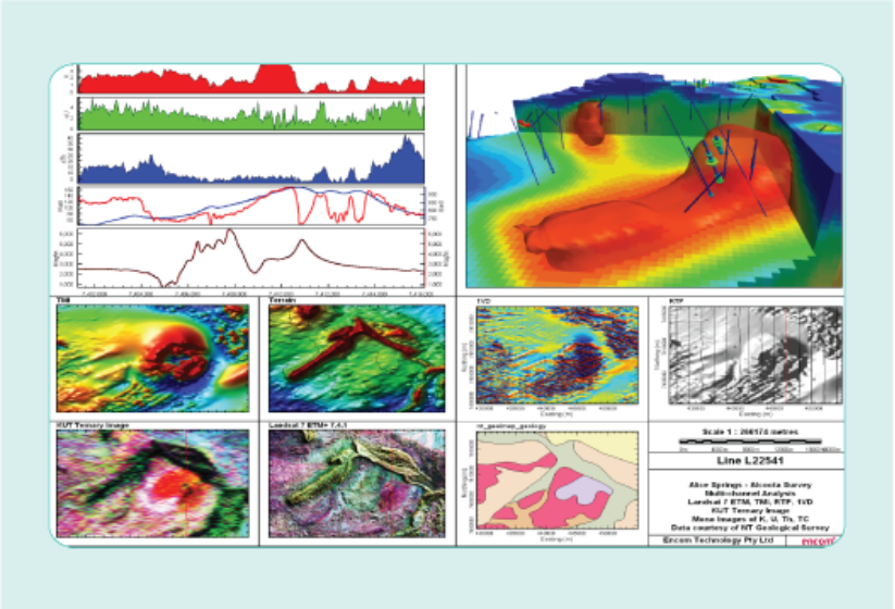
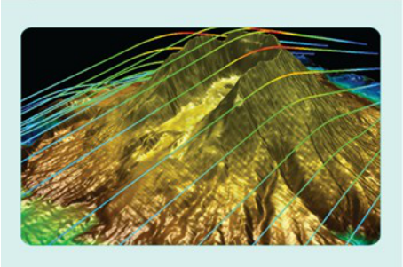
Visualize gravity and magnetics data in 1D、2D or 3D.
Gridding
-
Two-dimensional gridding: minimum curvature method, inverse distance weight method and triangulation method, etc.,
support the gridding of section data.
-
True there-dimensional gridding: layered map, inverse distance weight , discretization (lithology), there-dimensional Kriging.
-
Two-dimensional and three-dimensional toolboxes provide functions such as processing , fusion , computation and scripting of three-dimensional voxel models.
-
The volume element three-dimensional model can be combined with density or susceptibility data in ModeIVision.
-
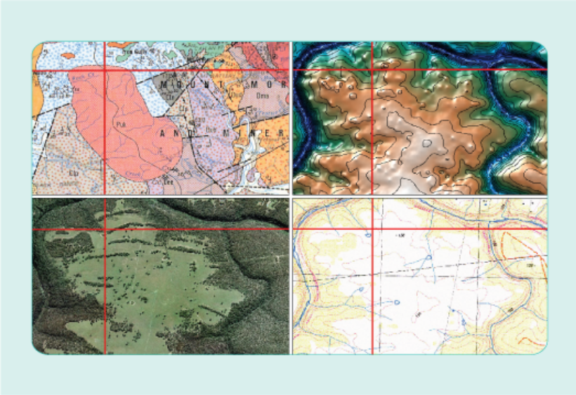
Assemble all kinds of two-dimensional data maps, including grid map , aerial photograph map, raster map, vector map, point data map and drilling data map.
Filtering and processing
-
Comprehensive FFT, convolution and non-linear filter functions can be used for line measurement data and two-dimensional mesh map.
-
Line filter: convolution, FFT and non-linear methods.
-
Convolitional filters: median filters,average filters, custom filters and 14 Standard non-liners.
-
Non-linear filters: AGC, median and noise methods.
-
FFT filter: band-pass, continuation, derivation, high-pass, low-pass, pseudogravity , pseudomagnetic susceptibility, red, polarization.
Two dimensional interpretation
-
Abnormal extraction: the target volume data are directly linked or extracted from plane, section , curve and three-dimensional volume element maps, and batch processing is carried out.
-
Interpretation elements: points, lines, polygons and so on. Draw these explanations on two-dimensional maps and synchronize them with other relevant two-dimensional or three-dimensional maps.
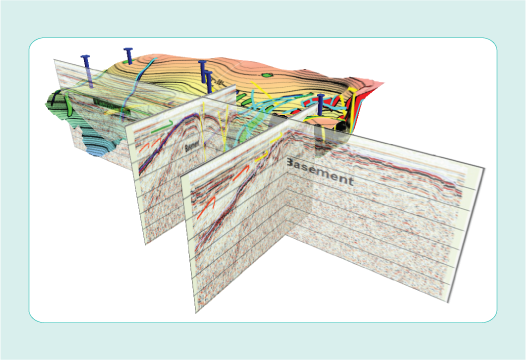
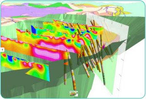
Three dimensional interpretation
-
Comprehensive geological interpretation results, comprehensive utilization of various geophysical data, inversion models, geochemical data and geological data.
-
Converting exploration data into exploration results, there is no guessing factor when you locate the drilling hole, and creating a three-dimensional target boby verified by geophysical data.
-
Create and edit three-dimensional geological surface and enclosed volume and ues them to build complex three-dimensional geological model. The velocity data can be simulated by using Encom PA seismic depth tool,and the results can be input into the three-dimensional map and comprehensively interpreted with other data.
Avionics Data Processing Interpretation
-
Display and exyract anomalies of multi-channel FEM and TEM data.
-
Comprehensive interpretation of the following data: track maps,CDI inversion profilght planning maps and other related images, such as seismic maps and geological profiles.
-
Display voxel model in section view and plane view.
-
Extracting anomalies from profiles, drawing interpretation results on CDI profiles , and then combining these continouos profiles to form a complete three-dimensional interpretation results.
Flight simulation
-
Comprehensive geological interpretation results,comprehensive utilization fo various geophysical data, inversion models geochemical data and geological data.
-
Converting exploration data into exploration results, there is no guessing factor when you locate the drilling hole and creating a three-dimensional target body verfied by geophysical data.


- 2026-07-29
- 2026-07-28
- 2026-07-26
- 2026-07-24
- 2026-07-23
- 2026-07-21

- 2026-07-30
- 2026-07-29
- 2026-07-29
- 2026-07-29
- 2026-07-29
- 2026-07-29