


ZondST2D
ZondST2D 是地球物探分析软件Zond的模块之一,是一款的二维地震反射软件。
ZondST2D设计与二维解释折射和反射波(陆地,跨孔和水变体)的地震层析成像数据。该软件以下模块:
-
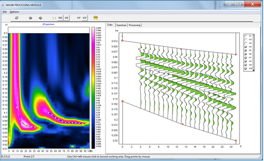
MASW / ReMi - 表面波数据处理和解释
-
折射波在任意层状介质中的正演和反演
-
衰减层析成像
-
速度各向异性
-
折射波和正演和在任意分层介质中反演
在地球物理学中,长期以来地震层析成像一词广为人知。这是由于以下事实:地震学的主要问题之一是逆运动学。它在于确定源到接受器的折射波在已知时间路径上的速度结构。在工程地球物理学中,受欢迎的是交叉孔地震层析成像。该方向用于钻孔空间中岩石速度结构的详细研究。
ZondST2d代表了地震层析成像的现成解决方案,解决了从数学建模和质量控制到现场处理和解释的广泛问题。方便的界面和数据可视化功能大程度地解决广泛的地质问题。
基本功能
-
在水面和水底的测量。经验和跨井眼系统。混合系统
-
指定地形的四种方法。实时编辑
-
5种型号的缓冲器
-
一组用于速度剖面数学建模的工具。标准网格“位图”样式,任意分层模型和多变形样式模型。用于总理,磁正向建模和联合反演的工具(Vp&VS,MASW,反射和折射,TDEM,VES,重力和磁)
-
反演算法的数量:平滑,聚焦,块。设置反演大的参考模型。反演期间的噪声分量的抑制(稳健的加权)
-
抑制反演期间的静态偏移
-
设置模型参数的限值,插入先验地质边界和井眼数据以进行反演。配置基准记录的权重。测量编辑。
-
基于铭感举证分析的结果质量评估。计算灵敏度,质量和DOI指数
-
数据,模型和先验信息可视化的变体数量。可以为电阻率部分(地质,地震部分)设置半透明背景
-
沿任意系统轮廓的速度剖面的三维可视化。映射深度的参数切片
-
地质剖面编辑器和钻孔柱编辑器。标题为钻孔
-
导出为位图和矢量图形格式,Excel,浏览器,AUTOCAD。设置导出图像的比例。打印图像并创建报告。
【英文介绍】
ZondST2d is designed for two-dimensional interpretation of seismic tomography data on refracted and reflected waves (land, cross-borehole and water variants).
The software includes the following modules: 1. MASW – surface waves data processing and interpretation, 2. Refraction waves forward modeling and inversion in arbitrary layered medium , 3. attenuation tomography, 4. velocity anisotropy, 5. Reflection waves forward modeling and inversion in arbitrary layered medium.
In geophysics, the term seismic tomography is known for a long time. This is due to the fact that one of the main problems in seismology - the inverse kinematics. It consists in determining the velocity structure at a known time path of the refracted waves from source to receiver. The most popular in engineering geophysics was crosshole Seismotomography. This direction is used for detailed studies of rocks velocity structure in the interborehole space.
ZondST2d represents ready solution for seismic tomography, and solves wide range of problems from mathematical modeling and quality control to field data processing and interpretation. Convenient interface and variety of data visualization features allow to solve wide range of geological problems with maximum effectiveness.

The software consists of two basic modules. One for the first times picking on the seismograms. The second is used for solving forward and inverse problems of seismic tomography.
For the seismograms processing developed a special interface designed to simplify and automate the process of first arrivals times picking. Special attention is paid to variety ways of data visualization and simple access to frequently used functions.

Solution of forward problem basis on special ray tracing algorithm of graph theory (Shortest path’s method). This algorithm is characterized by a high-speed calculations, and controlled accuracy.
ZondST2d uses simple and clear data format which allows easily combining various systems of observation, including different variants of the topography setting up and other additional information.
Important stage which prevents field measurement is mathematical modeling of velocity structure for seismic tomography survey. Modeling gives a chance to estimate the level of reflected waves first times and to make a choice of optimum parameters of the observation system for decision of formulated geological problem. ZondSt2d has great range of tools for mathematical modeling and analysis of refracted and reflected waves.

As the general task of the program is inversion of velocity parameters, some variants of seismic tomography inverse problem solutions are realized in ZondST2d, basic of them are: smoothing inversion – to get smooth model and focusing – to get piece-smoothed model of velocities with depth.

While program was designed special consideration given to a priori data accounting. Because of equivalence of inverse geophysical problems, quality of the obtained results strongly depends on the amount of a priori data used. In ZondST2d there is possibility of weights setting for measurements, fixing and limits making of changing features of different cells, using of a priori model as reference in inversion. The robust schemas of noise estimation are realized in the software. There is also possibility to import and display results of measurements by other methods and cross-boreholes data that improved quality of results.


- 2026-07-29
- 2026-07-28
- 2026-07-26
- 2026-07-24
- 2026-07-23
- 2026-07-21

- 2026-07-30
- 2026-07-29
- 2026-07-29
- 2026-07-29
- 2026-07-29
- 2026-07-29