


ZondRes3d - 三维电阻率成像软件
ZondRes3d 是地球物探分析软件Zond的模块之一,是一款三维高密度电法反演软件。
Zondres3d程序旨在对陆地,跨孔垫层析成像电阻率和感应数据进行三维解释和海洋变种。电层析成像是一种整体技术,包括现场观察方法,处理和现场数据解释技术。它的特点是多次重复使用 ,因为源和接收器只需固定在同一位置即可。这种方法一方面可以使用现代高性能仪器,另一方面可以应用有效的建模和反演算法。为了解释电子断层扫描数据,使用了二维和三维模型。由于与“经典”水平分层有很大的调查部分,它扩展了电力勘探解决问题的范围。电子断层扫描的分辨率和解释质量与一个站点的测量数据和密度密切相关。它们的数量通常达到一千,这就是为什么关于现场测量效率的问题具有根本性,并且在某些方面定义了这种方法的实际使用可能性的原因。为了达到现场工作效率,使用了具有自动编程的电自动切换功能的特殊设备。三维电子断层扫描技术是一种特殊的测量技术,同时测量数量达到一万次。但是在很多情况下,对于三维解释,使用在几条平行轮廓线上接收到二维电子断层扫描。
ZondRes3D程序的特点是其高资源利用与需要计算机的大尺寸正反问题解决方案的特殊性联系在一起。在程序中实现了两种解决电场计算正反问题的方法 - 有限元法和有限差分法。有限差分法的工作速度大约快2倍,但不允许使用地形。
ZondRes3d代表了电子断层能扫描的现成解决方案,解决了从数学建模和灵敏度分析到现场数据处理和解释的广泛问题。便捷的界面和各种数据可视化功能大程度解决各种地质问题。
ZondRes3d使用简单明了的数据格式,可以轻松组合各种观测系统,包括地形设置的不同变体和其他附加信息。该程序适用于一些类型的电阵列(应用于电勘探)或其组合,还支持众所周知的数据格式。
【英文介绍】
ZondRes3d program is designeed for three-dimensional interpretation of electrical tomography resistivity and induced polarization data in land, cross-borehole and marine variants.
Electrical tomography is a whole technique including the method of field observations and technology of processing and field data interpretation. Its feature is multiple reusing as a source and receiver just the same electrodes position, fixed on a site.
Such approach allows from one hand to work with a modern high-performance instruments, and on the other hand to apply effective algorithms of modeling and inversion. For interpretation of electrical tomography data two- and three-dimensional models is used . It significantly extends the range of electric prospecting solved problems due to sections investigating that are considerably different from «classic» horizontal-layered.
Resolution and thus interpretation quality of electrical tomography is closely connected with the number and density of measurements on one site. Their number usually reaches first thousand that is why the question on field measurements efficiency has basic importance and in many aspects defines possibility of practical using of this method. Special equipment with programmed automatic switching of electrodes is applied for reaching of maximum effectiveness of field works.
The technique of three-dimensional electrical tomography means a special measurement technique with use of a considerable number of switched electrodes (some electric prospecting cables) while number of measurements reaches ten thousand. But in many cases for three-dimensional interpretation it is enough to use the results of two-dimensional electrical tomography received on several parallel profile lines.

Feature of ZondRes3d program is its high resource using connected with specificity of the forward and inverse problem solution of big dimension that requires powerful computer. Two methods of solving forward and inverse problem of electric field calculation are realizes in the program – method of finite elements and method of finite differences. The method of finite differences works approximately twice faster, but doesn’t allow use a topography.
ZondRes3d represents ready solution for electrical tomography, and solves wide range of problems from mathematical modeling and sensitivity analysis to field data processing and interpretation. Convenient interface and variety of data visualization features allow solve wide range of geological problems with maximum effectiveness.
ZondRes3d uses simple and clear data format allowing easily combine various systems of observation, including different variants of the topography setting up and other additional information.
The program works with any (applied in electric prospecting) types of electrodes array (two, three and four – electrodes) or their combinations. Well-known data formats are also supported.

Special mode for working with middle gradient array is provided that allows to calculate quickly and visualize data in the form freandly for the interpreter.
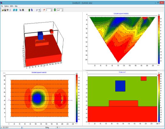
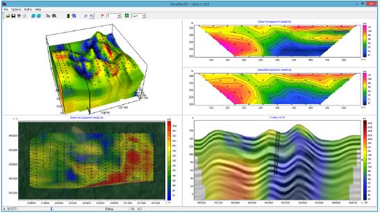
Some variants of three-dimensional model display in the form of various sections and isosurfaces are realized in the program.
Important stage which prevents field measurement is mathematical modeling of geoelectric structure of work site. Modeling gives chance to estimate the level of the signal and to make a choice of optimum parameters of the observation system for decision of the set geological problem. ZondRes3d has great range of tools for mathematical modeling and analysis of fields sensitivity of DC and induced polarization.
As the general task of the program is inversion for geoelectric section parameters – some variants of inverse problem decision are realized in ZondRes3d; basic of them are: smoothing inversion – to get smooth and focusing – to get piece-smoothed distribution of geoelectric parameters with depth.
While working out at the program special attention was paid to a priori data accounting. Because of equivalence of inverse geophysical problems, quality of the obtained results strongly depends on the amount of a priori data used. In ZondRes3d there is possibility of weights setting for measurements, fixing and limits making of changing features of different cells, using of a priori model as major in inversion. The robust schemas of noise estimation are realized in the software. There is also possibility to import and display results of measurements by other methods and cross-boreholes data that improve interpretation results.


- 2026-06-18
- 2026-06-12
- 2026-06-12
- 2026-06-12
- 2026-06-05
- 2026-05-28

- 2026-06-11
- 2026-06-11
- 2026-06-11
- 2026-05-28
- 2026-05-28
- 2026-05-28